
History of San Felipe: Gulf of California
![]()
THE HISTORY OF SAN FELIPE, BAJA CALIFORNIA, MEXICO
CHAPTER III: GULF OF CALIFORNIA
Separated from the Pacific Ocean by the mountainous peninsula of Baja California lies the long, narrow basin of the Gulf of California. The east shore is bordered by a narrow coastal plain backed by the Sierra Occidental of Mexico. From Cape San Lucas to the Colorado Delta, the Gulf is 600 miles long: throughout this length the body of water averages less than 100 miles in width. The northern region of this finger-like body of water, particularly the delta and area adjacent to San Felipe, is the area of concentration for this study.
I. SUBMARINE TOPOGRAPHY
The Cretaceus and Pre-Cretaceous bedrock structure of the northern gulf is masked under 5,000 to 7,000 feet of sediment, most of which has been deposited by the Colorado River, particularly during the post-pleistocene sea-level rise. [Tjeerd H. Van Andel, Recent Marine Sediments of the Gulf of California (A Symposium, Marine Geology of the Gulf of California, ed. Tjeerd H. Van Andel and George Shor, Jr., Published: The American Association of Peetroleum Geologists, 1964, p. 272.] The depositional materials are composed mainly of arkose and small amount of volcanic debris. [Ibid.]
|
|
The sand makes for a very regular subsurface topography. The only irregularity in the northern gulf is found at Consag Rock, a very small granitic island that pierces the sand mantle. This island, with an elevation of 286 feet, lies near the head of the gulf and is only three or four kilometers in length. It is solely the home of sea fowl.
II. EVAPORATION AND SALINITY
The Gulf of California is like a huge evaporation pan. Water masses entering the Gulf from the Pacific Ocean are modified at the surface by extensive evaporation, which increases salinity. Evaporation is intensified towards the northern reaches of the gulf. Fresh water from the Colorado has little effect upon the salinity of the northern Gulf.
III. WATER TEMPERATURE AND CURRENTS
Surface temperatures in the gulf range between 57°F. (14°C.) and 70°F. (21°C) in February and between 84°/f, (28°C.) and 88° (31°C.) in August. [G.I. Roden. Oceanographic Aspects of the Gulf of California (A syposium Marine Geology of the Gult of California) ed. Tjeerd Van Andel and George Shor, Jr. Published: Th eAmerican Association of Petroleum Geologists 1964) p. 30.] Gulf currents have a definite effect upon the water temperature. Surface water temperatures differ between the eastern and western shores of the Gulf. This temperature difference is directly related to seasonal wind shifts. The winter position of the low pressure cell over Mexico's mainland coast attracts northwesterly winds. These winds cause gulf surface currents. Under the winds' directional force, the currents strike the mainland coast at a high oblique angle. The current is deflected away from the shore, and this westerly moving water must be replaced. The only source is deeper, cooler water from the depths of the gulf which rises to the surface to form zone upwelling. As a result of the upwelling, winter water temperatures along Mexico's mainland shore are lower than those of the Baja California shore. In summer, southeasterly winds are attracted by a low pressure cell over the mouth of the Colorado River. This repositioning of the cell leads to upwelling and therefore water temperatures along the Baja California shore are cooler in relation to those along the mainland shore.
IV. TIDES AND SEA LEVEL
The composite tidal range increases gradually from the Gulf entrance to Isla Tiburon, and then rapidly to the mouth of the Colorado. The latter experiences a spring tidal range of 10 meters, an average range of 7 meters, and a neap range of 2 meters. [Ibid., p. 38.]
During periods of high range, tidal waves 1.5 to 3 meters high move up the Colorado River intensifying in mass and motion resulting from the river's narrow channels. Immense pressure is therefore built up in the distributaries of the Rio Colorado. A wall of tidal water races upstream causing the river to reverse its flow resulting in a tidal bore.
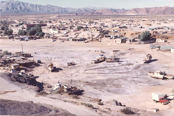
High tidal ranges in the northern gulf have both a beneficial and a detrimental effect upon San Felipe. Periodically, high tides fill a low-lying area behind the beach ridge at San Felipe allowing for natural dry-docking facilities. At high tide, fishing vessels in need of repairs pass into the tidal lagoon. The lagoon empties at low tide leaving the boats on the sand. This occurrence was a major attraction for commercial fishermen (plate 5). Inversely, the exceptionally high tidal ranges can have a detrimental effect on plans for construction of a pier or marina at San Felipe. If construction is seriously considered, docking facilities and boat protection marinas would have to be constructed far enough into the bay to provide deep water at low tide.
|
Plate 5. Fishing Boats in for Repairs at San Felipe's Natural Dry Dock. |
V. MARINE LIFE
Massive populations of fish and other sea creatures have come to the Gulf of California with good reason. For millions of years the Colorado River has carried minerals and organic matter from the far reaches of the Rocky Mountains and deposited them in the Gulf. Chemicals and chlorophyll combine an excellent marine environment, to generate the growth of tremendous populations of microscopic marine plankton, the basic food supply for most marine creatures. The gulf's water temperature, coupled with this excellent food supply, has lured thousands of varieties of tropical fish to its waters. These fish have in turn, lured many fishermen to the Gulf of California.
At the northern end of the Gulf, the most important commercial fish is the totuava. The totuava is a croaker of the species (Cynoscion macdonaldi), largest member of the family (Sciaenidae) and belongs to the subgenus (Cynoscion). They superficially resemble the Pacific white sea bass, (Cynoscion nobilis) and often reach a weight of 170 pounds, occasionally approaching 300 pounds. The totuava swim up the gulf in order to spawn in the mouth of the Colorado, where their fertilized eggs are carried by tidal bores well up the Colorado River into brackish water. While deposited here, the eggs are protected from salt water predators. [J.A. Craig, "A New Fishery in Mexico", California Fish and Game XII. (October, 1926). 166.]
Totuava became important for commercial interests near the turn of the century. Since then, the concentrations of totuava at the northern end of the gulf have played an important part with the early settlement and current economy at San Felipe.
TABLE OF CONTENTS: HISTORY OF SAN FELIPE SITE EVOLUTION, BY THOMAS ANTHONY TERICH
(Related San Felipe articles and reports may be found at Mexfish.com's main San Felipe information page. See weekly fishing news, photos, and reports from the major sportfishing vacation areas of Mexico including the San Felipe area in "Mexico Fishing News.")
MEXICO FISHING INFO SAN FELIPE FISHING INFO "WEEKLY MEXICO FISHING NEWS" FISH PHOTO GALLERY