
History of San Felipe:
Physiography of Northeastern Baja California
![]()
THE HISTORY OF SAN FELIPE, BAJA CALIFORNIA, MEXICO
CHAPTER IV: PHYSIOGRAPHY OF NORTHEASTERN BAJA CALIFORNIA
A series of mountains composing Peninsular Ranges extends from Southern California to nearly the southern cape of Baja California. In California the mountains include the San Jacinto, Santa Rosa and Santa Ana Mountains.
|
|
South of the border, the individual groups of mountains forming the Peninsular Ranges are called Sierras. The principal sierras for the northern part of the peninsula are the Sierra Juarez and Sierra San Pedro Martir.
The principal features east of the Peninsular Range in Baja California are the Laguna Salada whose bottom lies at sea level, the Sierra de los Cocopahs, the Sierra Mayor, and the delta and flood plain of the Colorado River. All of the above features lie in the area termed the "Colorado Desert".
Between the delta of the Colorado River and the depressed basin of the Laguna Salada, lie the arid Sierra de los Cocopahs and Sierra Mayor. These Sierras separate the flood plain of the Rio Hardy, a distributary of the the Colorado, from the Laguna Salada, a vast, barren plain that becomes inundated when the high tides of the gulf meet the annual Colorado River floods. The faulted Sierra, rising 3500 feet, appear as islands of ancient rocks in a sea of alluvium. (fig. 6).
|
Figure 6. Physiography of Northeastern Baja California. |
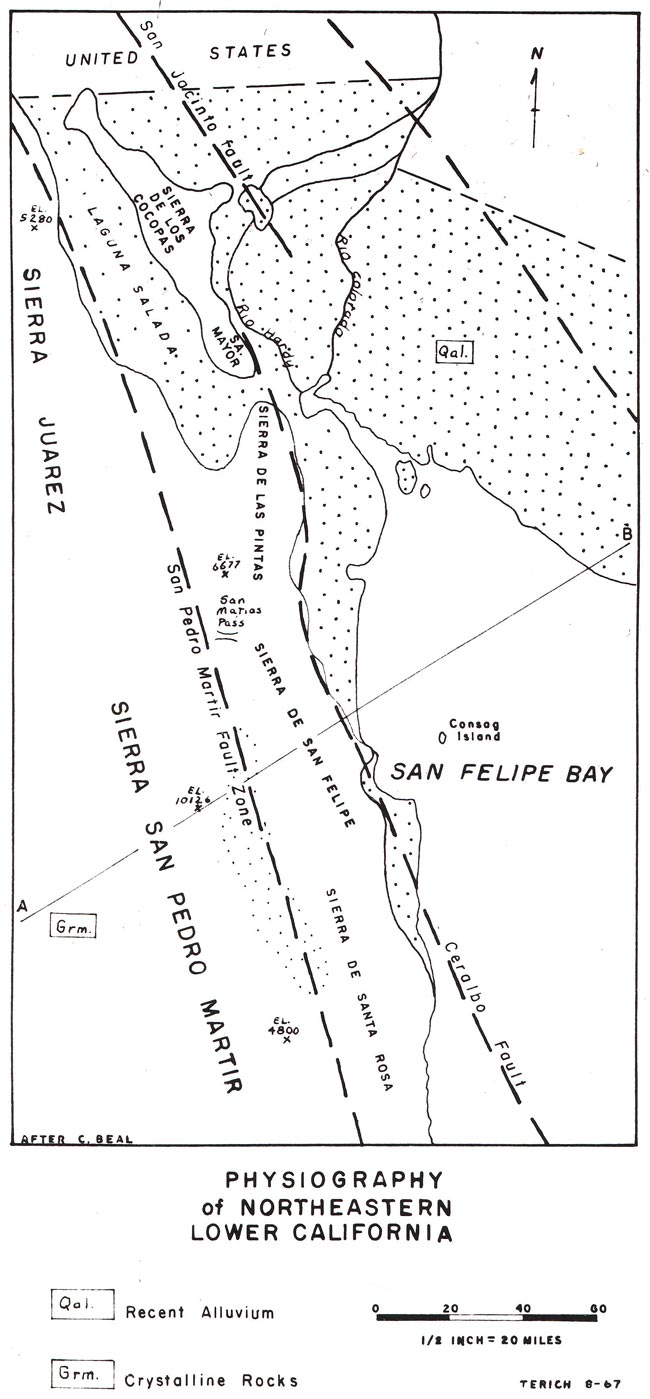
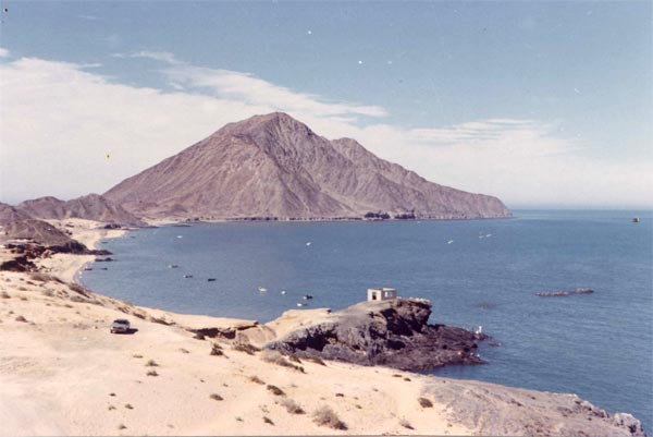
Farther south the Sierra de la Tinaja, Sierra de las Pintas, Sierra San Felipe and Sierra Santa Rosa parallel the Peninsular Ranges, but are separated from the Ranges by the Valle de San Felipe. A portion of the Sierra San Felipe extends into the gulf forming the northern point of San Felipe Bay. This outlier is 940 feet high and is known as San Felipe Point (plate 6).
|
Plate 6. Point San Felipe Extends into the Gulf Just North of the Village. |
The sierras of the northern region of San Felipe are composed of Cretaceous and Pre-Cretaceous crystalline rocks such as quartz, diorite, granodiorite, schists, gneisses and associated rocks. [Carl H. Beal, Reconnaissance of the Geology and Oil Possibilities of Baja California, (Baltimore Geological Society Memoir No. 31, 1948) p 35.] The gently sloping sea of Recent Pleistocene alluvium aprons extend out from the base of the sierras to form the undulating surface of the Desierto de San Felipe or more locally known as Desierto de los Chinos. This desert lies between the eastern base of the Sierra and the gulf. The Desierto de San Felipe and adjacent Colorado River delta and Sonoran Desert form the cul-de-sac of the Gulf of California.
II.EVIDENCE OF FAULTING
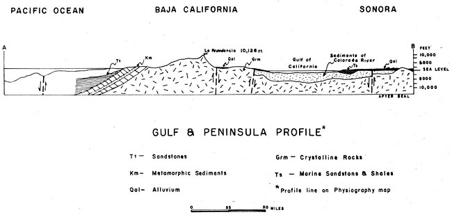
The block of which the peninsula is the crest, appears to be an elevated mass with reference to the gulf trough on the east and the bed of the Pacific Ocean beyond the continental slope fault on the west. Carl Beal hypothecates that this strip of the earth's crust was elevated by compressive forces acting normal to the crust, and that parallel faults on the east and west flanks of the peninsula were formed at that time. [Ibid., p 91.] (fig. 7).
|
Figure 7. Gulf and Peninsula Profile. |
The major eastern fault, known as the Ceralbo fault, parallels the entire east coast of Lower California slashing San Felipe, amputating Point San Felipe from the main body of the Sierra.
Fault Scarps. The steep faces of the Sierra Mayor, Sierra Pinta and Sierra San Felipe exhibit topographical evidence of faulting along their flanks. Beal also states there is much evidence of faulting along the east coast of the peninsula north of San Felipe. This coast is characterized by high scarplike sea cliffs possibly of fault origin. [Ibid., p. 93.]
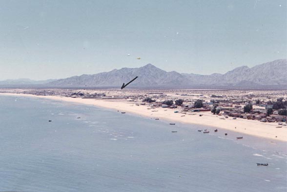
The sea cliffs are composed of cemented arkosic sand and are perhaps thirty feet high. South of Point San Felipe they resemble little more than sloping bluffs fifteen feet high, paralleling the shore two hundred yards inland (plate 7 and 8). Small volcanic outcrops generally follow the ridge giving support to the hypothesis of faulting.
|
Plate 7. A Beach Ridge Parallels the Shore at San Felipe. |
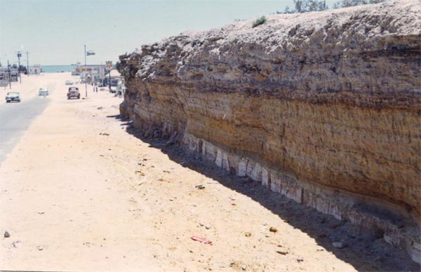
|
Plate 8. Sedimentary Layers Exposed in the Beach Ridge. |
Water Traps. Fresh water with little saline influences can be had at a depth between 10 and 20 feet. The lack of salt water intrusion may be due to a fresh water trap caused by a disconformity of aquifer sedimentaries as a result of movement along the fracture.
Near shore thermal activity suggests a weakness in the earths's crust owing to the fault. Sea water temperature definitely increases with depth in the sand lying within the tidal range, giving further support to Beal's hypothesis.
The Ceralbo fault continues south to Puertocitos where hot springs reveal its possible presence. This is the last land evidence of the fault, but an offshore marine trench parallels the peninsula revealing the wound in the earth's crust.
III. DIFFERING EXPLANATIONS OF THE PHYSIOGRAPHY
Other writers such as Fred Kniffen and Godfrey Sykes conclude that the sea cliffs are features caused solely by the action of waves and currents of the gulf. The inland bluffs at San Felipe are dunes or old wave cut terraces. The presence of fresh water is due to coastward sloping sedimentary beds, which carry mountain water under great hydrostatic pressure to the shore preventing active salt water intrusion. Active thermal hot springs and volcanic knobs are the result of the San Andreas fracture, which is buried under the gulf's alluvium.
TABLE OF CONTENTS: HISTORY OF SAN FELIPE SITE EVOLUTION, BY THOMAS ANTHONY TERICH
(Related San Felipe articles and reports may be found at Mexfish.com's main San Felipe information page. See weekly fishing news, photos, and reports from the major sportfishing vacation areas of Mexico including the San Felipe area in "Mexico Fishing News.")
MEXICO FISHING INFO SAN FELIPE FISHING INFO "WEEKLY MEXICO FISHING NEWS" FISH PHOTO GALLERY