
![]()
Sparky jumped
times
before he retired.
Good job, Sparky!
KING OF THE MOON
A Novel of Baja California
Amazon Kindle Book $2.99
FISH PICTURES
Fish Species From Mexico
MEXICO TRAVEL
FISHING LOCATIONS
MEXICO FISHING
Report Weekly Archives
THE UNFORGETTABLE
SEA OF CORTEZ
Baja's Golden Age
Limited Edition
Second Printing
THE BAJA CATCH
Classic Baja Fishing
Guidebook, More Than
20 Years In Print!
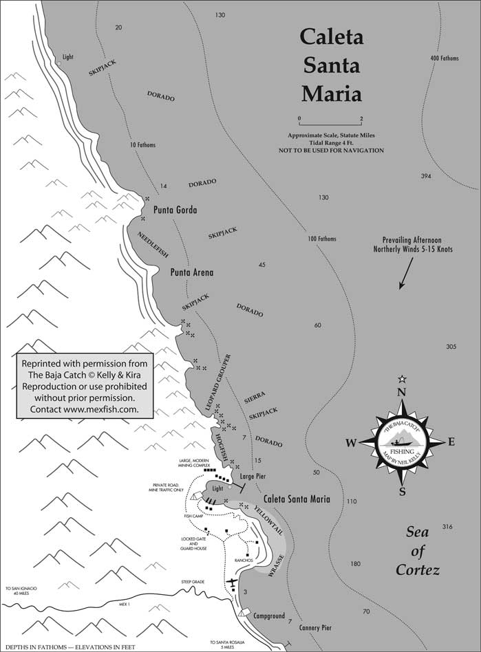
Caleta Santa Maria Fishing Map (Santa Rosalia Area), Baja California Sur, Mexico
Fishing The Sea Of Cortez Coast At Caleta Santa Maria, Santa Rosalia, Mexico
This fishing map for Caleta Santa Maria, Sea of Cortez coast, Baja California Sur, Mexico, shows some important fishing grounds of pangas and boats working out of the Santa Rosalia fishing area and other nearby Baja fishing locations.
Principle sportfishing areas shown on this map include: Punta Gorda, Punta Arena, and Caleta Santa Maria with its large mining complex, just north Santa Rosalia.
Current and archived weekly fishing reports for Caleta Santa Maria and other important Baja and mainland Mexico fishing vacation destinations, including fish species caught during each season, fish counts, sportfishing operations, weather conditions, sea water temperatures, and other sportfishing information may be found online each week in Mexico Fishing News.
This Caleta Santa Maria fishing map is reprinted with permission from the Baja California fishing guidebook, The Baja Catch: A Fishing, Travel & Remote Camping Manual for Baja California, Third Edition, by Neil Kelly and Gene Kira.
This is one of 60 detailed fishing maps in The Baja Catch showing small boat fishing and launching locations on the Pacific and Sea of Cortez coasts of Baja California, Mexico. Reproduction of this Caleta Santa Maria map is prohibited without prior permission.
(Related Santa Rosalia articles and reports may be found at Mexfish.com's main Santa Rosalia information page. See weekly fishing news, photos, and reports from the major sportfishing vacation areas of Mexico including the Santa Rosalia area in "Mexico Fishing News.")
Mexico Fishing Home Page < Santa Rosalia Contents < Report
Copyright ©