
Gonzaga Bay Area Fishing Map
![]()
FISHING THE SEA OF CORTEZ IN THE GONZAGA BAY AREA, MEXICO
Gonzaga Bay Area Map
(San Felipe Area, Northern Sea of Cortez)
Baja California, Mexico
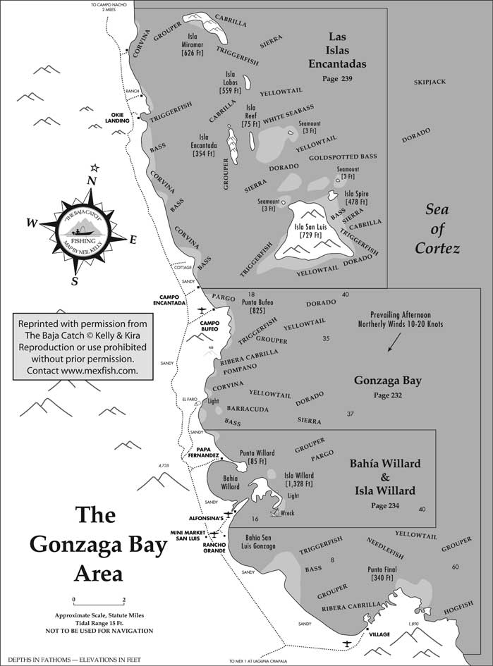
This fishing map for the greater Gonzaga Bay Area, Sea of Cortez coast, Baja California, Mexico, shows some important fishing grounds of pangas and boats working out of the San Felipe fishing area and other nearby Baja fishing locations.
|
|
Principle sportfishing areas shown on this map include: The Islas Encantas group, including large Isla San Luis, Punta Bufeo, Bahias Willard and San Luis Gonzaga, and Punta Final.
Current and archived weekly fishing reports for Gonzaga Bay Area and other important Baja and mainland Mexico fishing vacation destinations, including fish species caught during each season, fish counts, sportfishing operations, weather conditions, sea water temperatures, and other sportfishing information may be found online each week in Mexico Fishing News.
This Gonzaga Bay Area fishing map is reprinted with permission from the Baja California fishing guidebook, The Baja Catch: A Fishing, Travel & Remote Camping Manual for Baja California, Third Edition, by Neil Kelly and Gene Kira.
This is one of 60 detailed fishing maps in The Baja Catch showing small boat fishing and launching locations on the Pacific and Sea of Cortez coasts of Baja California, Mexico. Reproduction of this Gonzaga Bay Area map is prohibited without prior permission.
(Related San Felipe articles and reports may be found at Mexfish.com's main San Felipe information page. See weekly fishing news, photos, and reports from the major sportfishing vacation areas of Mexico including the San Felipe area in "Mexico Fishing News.")
MEXICO FISHING INFO SAN FELIPE FISHING INFO "WEEKLY MEXICO FISHING NEWS" FISH PHOTO GALLERY